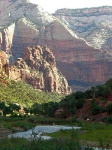
 Geologically situated between the ancient Grand Canyon and relatively youthful Bryce, Zion National Park is the “middle step” in the geological feature known as the Grand Staircase. Tucked into the southwest corner of Utah, it is the state’s oldest and most heavily visited National Park. Although Zion is known more for its canyoneering and short, steep hikes to jaw-dropping vistas, miles of beautiful, lonesome trails await the runner willing to tap into the park’s backcountry.
Below we’ll provide you with examples of easy, moderate, and advanced trail runs in Zion. We also include a special section of classic “cliff runs” for runners who like to chase vert. After giving you some example runs, we’ll let you know where to get gear and a bite to eat, as well as where you can find additional resources.
As always, if you’ve run in Zion, please share your favorite or most memorable experiences. Have a resource to share? Leave a comment! Have a question? Lay it on us. We’ll do our best to get you an answer.
Easy Trail Run – Pa’rus Trail
There’s no sugar-coating it: Zion is not particularly well-stocked with easy trail running options. From the bottom of Zion Canyon, most trails over a mile in length point steeply up the side of cliff walls. And running just a short segment of one of the shallower backcountry trails (listed below) lacks appeal because getting to their trailheads requires a significant drive from Zion Canyon or the nearby town of Springdale.
However, if you are looking for a good option to stretch your legs and get a small taste of the park, you might try the Pa’rus Trail. This paved trail starts from the South Campground next to the park entrance and follows the Virgin River to Canyon Junction. The roundtrip is 3.5 miles and elevation change is negligible.
Insider’s Scoop: Across the river from the Pa’rus Trailhead is the starting point of another nice, short trail called Watchman. In a bit over a mile, this trail makes a moderate climb (about 350 feet) to a nice viewpoint beneath the Watchman spire. Or, if you stay inside the park at Zion Lodge, you can link the Grotto and Emerald Pool trails for a roughly 3-mile loop.
Moderate Trail Run – Kolob Arch
The northwest section of Zion, known as Kolob Canyons, is almost a mini-park unto itself. For one thing, it can only be reached from the rest of the park via the Hop Valley Trail. Auto access is via I-15 about half-way between St. George and Cedar City (roughly 45 minutes one-way from Springdale). The color of the sandstone and the vegetation in Kolob Canyons are also slightly different from the rest of the park, which adds to its distinctive feel.
The trail running jewel of this corner of the park is the La Verkin Creek Trail to Kolob Arch. From the Lee Pass Trailhead, the trail descends about 1,000 feet in four miles to La Verkin Creek. The trail then follows the meandering path of the creek another three miles to the junction with the Kolob Arch Trail. From there, a half-mile scramble up the narrow canyon deposits you below the arch. Kolob Arch may not be the most stunning arch, but, at nearly 300 feet across, it is one of the longest. After you’ve soaked it in, simply reverse course to Lee Pass, or, if you arrange a shuttle, you can cross the creek and take the Hop Valley Trail to its trailhead on the Kolob Terrace Road. (From the arch, the distance is the same whether you backtrack to Lee Pass or run through on the Hop Valley Trail.)
Insider’s Scoop: Most maps say the round trip to Kolob Arch from Lee Pass is 14 miles. My GPS running watch always returns a total of 15. GPS reception is spotty in the Kolob Arch box canyon, but that doesn’t seem like adequate explanation of the discrepancy.
If the Kolob Arch route doesn’t quite “fit your budget,” there’s a sort of miniaturized version of the run just a few miles away in the same Kolob Canyons section of the park: the Taylor Creek Trail offers similar appeal as Kolob Arch, but is either a five-mile round trip if you stick with the straightforward Middle Fork, or seven plus miles if you elect to follow the North Fork branch of the trail.
Cliff Running – Angel’s Landing
Mountain runners looking to go vertical will find an embarrassment of riches in Zion. The most famous route by far is Angel’s Landing. Even with the flat warm-up alongside the river, and another shallow section through Refrigerator Canyon, the trail climbs 1,500 vertical feet in 2.5 miles, and includes a white-knuckle shimmy up a sandstone fin to trail’s end. (Angel’s Landing is a spur off the West Rim Trail about 2 miles from its terminus at the Grotto Trailhead. Keep that in mind as you consider the Advanced runs described below.)

Zion Canyon from the trail to Angel’s Landing. About a third of the way up, just before entering Refrigerator Canyon.
Insider’s Scoop:
Want to go bigger? No problem. Next size up from Angel’s Landing is Observation Point, which climbs 2,150 feet in 4 miles and is not nearly as crowded or precarious as Angel’s Landing.
Want to go smaller? Also not a problem. At a “mere” 850 vertical feet in one mile, a great teaser cliff run is Hidden Canyon. While the run may be smaller, the payoff here is still great: the namesake hanging canyon where the trail ends is definitely a Zion favorite. Scramble as far up “the trail” as your skills comfortably permit before turning around.
Both Observation Point and Hidden Canyon start at the Weeping Rock Trailhead. The spur to Hidden Canyon is about 1/2 mile from the start.
Advanced Trail Run – Zion Traverse (ZT)
Simply put, this route is good as it gets. 48 miles and total climbing of roughly 10,000 feet. Long stretches of classic western singletrack through wooded terrain, a few sand traps to remind you you’re in the desert, plus several cliff-side sections that may make your stomach do somersaults.
Mileage of individual trail segments (Lee Pass TH to East Entrance TH)
La Verkin Creek: 6.7
Hop Valley: 6.7
Connector: 3.4
Wildcat Canyon: 4.7
West Rim: 14.9
Canyon Road: 1.0
East Rim: 10.5
Much of the route consists of more-or-less rolling terrain. The major exception is the descent/climb involving Zion Canyon. (Peak-to-trough elevation change is 3,000+ feet. Not quite Grand Canyon Big, but big nonetheless.)
Insider’s Scoop: Running from west to east means a slight (400 feet) net loss of altitude and a (sandy) mellow descent to finish off, but also means you start the march out of Zion Canyon at mile 39. Completing the Traverse requires a bit of planning and mid-run support. You can arrange for the latter independently or use a local guide/shuttle service.
Opting for a shorter run by simply picking off one or more of the individual ZT segments is another great alternative. Particularly lovely is a “Mini Traverse” starting either at Lee Pass or Wildcat Trailhead and ending at the Grotto Trailhead (West Rim terminus). You’ll cover 38 or 21 miles, respectively, which you can polish off with an icy soak in the Virgin River smack in the heart of Zion Canyon. Sublime.
Get Your Gear:
Springdale at the mouth of Zion Canyon, just outside the main park entrance. If you make Springdale your base camp, it’s best to come pretty well prepared. It’s a very small town with no running-oriented stores. However, if you overlook something or have last-minute needs, you may be able to find what you need at one of the small general outfitters like Zion Outdoor.
St. George is about 45 minutes from ZNP. The options you would expect from a small city of about 100,000 people. Chains include Sportsman’s Warehouse and Big 5. The Desert Rat is primarily focused on climbing and hiking, but probably no one in the area knows Zion better than the owner, Bo Beck. The local running store, St. George Running Center, is good, if road-centric.
Get Your Grub On:
Springdale: Plenty of good options. Very few chains, if any. Better availability of coffee and adult beverages than St. George. You will generally not go wrong with: Blondie’s for sandwiches or burgers; Zion Pizza & Noodle Company for, you guessed it, pizza and pasta; Oscar’s or Bit & Spur for Mexican slash southwestern; and Parallel Eighty-Eight for a splurge.
Springdale also has a decent (if small) grocery store, called Sol Foods, located just across the footbridge from the ZNP Visitor’s Center. If your timing is right, you may also be able to pick a few apples from the orchards of the Springdale Fruit Company.
St. George: Putting aside the many chains, options include Bear Paw Coffee Company (breakfast), Twenty-Five Main (lunch), Basila’s (Mediterranean), Benja (Thai, sushi), The Painted Pony (southwestern), Scaldoni’s (Italian) and Nielsen’s Frozen Custard (smoother than ice cream).
Additional Resources/Need to Know
- Joe’s Guide to Zion National Park – A very good guide to the trails of Zion (including topo maps) and the photo galleries are outstanding.
- Bo Beck’s Zion Website – Descriptions, maps, etc. compiled by the owner of St. George outfitter The Desert Rat. Also a good resource for other regional gems like Grand Canyon, Bryce Canyon, Cedar Breaks, and Grand Staircase-Escalante.
- Of the various accounts and descriptions I’ve come across, Andrew Skurka’s Meticulous Trip Planning Guide is probably the most useful resource for ultrarunners intent on tackling the full Traverse.
- If speed is your thing, you may be interested to know that the Zion Traverse Fastest Known Time is owned by Matt Hart, is 7:58.
- Bringing your car to ZNP – April – October, no private car traffic* is allowed in Zion Canyon north of its junction with the Mt. Carmel Highway. Instead, hop on a free ZNP-Springdale shuttle bus to get to/from Canyon trailheads. (*Exception: guests of Zion Lodge.)
- Wildcat Canyon Trail – One afternoon running out-and-back on one of the park’s best kept secrets.
- Weather – It gets very, very hot in ZNP during the summer. Shade and natural water sources can both be quite scarce, especially on the mesa tops where much of the best trail running is. Winter brings a considerable amount of snow to the higher elevations. Snowshoeing is a great option during winter, as is a run on one of the lower-elevation trails — like Chinle — that remain dry year-round and are unmercifully hot during the summer.
- Maps – ZNP’s official guide (pdf) is a good starting point for getting the lay of the land. For more detailed guidance, you might consult National Geographic’s (#214) Zion map. (You may also have noted that Joe’s Guide, which we’ve linked to liberally, also has good maps of individual trails.)
Please leave a comment letting us know of other valuable trail running resources in and around Zion National Park!
![]() [Stacy Young is a trail runner based in St. George, Utah. He also heads the Wilderness Running Company, an online retailer that specializes in trail running shoes, apparel, and accessories.]
[Stacy Young is a trail runner based in St. George, Utah. He also heads the Wilderness Running Company, an online retailer that specializes in trail running shoes, apparel, and accessories.]


